
Submissions/Humanitarian OpenStreetMap mapping workshop
|
This is an accepted submission for Wikimania 2014. |
- Submission no. 8020
- Title of the submission
Humanitarian OpenStreetMap mapping workshop
- Type of submission (discussion, hot seat, panel, presentation, tutorial, workshop)
Workshop
- Author of the submission
- E-mail address
- Username
aude
- Country of origin
Germany
- Affiliation, if any (organisation, company etc.)
Humanitarian OpenStreetMap Team
- Personal homepage or blog
- Abstract (at least 300 words to describe your proposal)
OpenStreetMap project is a free and open source, editable mapping project that started in 2004. OpenStreetMap is more than mapping streets, with a variety of features and details mapped such as disabled access to restaurants and details important for accessible routing. The data is open source (under the Open Database License) and can be used to make maps for Wikipedia.
OpenStreetMap has also been used in disaster response and other aspects of humanitarian response and economic development. Following the 2010 Haiti earthquake, the OpenStreetMap community quickly filled in coverage of Haiti, including details like earthquake damage and camps. By far, OpenStreetMap had the best mapping data available for Haiti and was used by disaster response organizations there. Since then, the Humanitarian OpenStreetMap Team (H.O.T.) was established to help provide support for such community efforts and put a structure in place for working with other organizations, such as the World Bank. H.O.T. and the OpenStreetMap community has responded to numerous other disasters, including the 2011 Tōhoku earthquake and tsunami in Japan. H.O.T. is engaged in other projects around the world, notably in Indonesia and many countries in Africa, and has continued efforts working with communities in Haiti.
We will give an overview of the types of mapping and tools for editing OpenStreetMap, including the iD and JOSM editors. Then we will introduce tools used to help coordinate humanitarian mapping, specifically the H.O.T. tasking manager, which helps divide a mapping task into smaller pieces that many mappers can work on and includes a step to validate the mapping. Depending on the area, the type of response and availability of imagery, one might do mapping based on imagery made available by Bing, or use another imagery source that H.O.T. obtains. In the field, mappers may use "walking papers" / "field papers", which consists of a print-out of OpenStreetMap which can be annotated. It can then be scanned and uploaded, and be referenced in the OpenStreetMap editors when entering the map data. Field mappers may also use GPS, take video and other methods of collecting information to fill in details that cannot be entered remotely by tracing imagery.
The main part of the session will be hands-on mapping for a H.O.T. project. We will select a H.O.T. project that needs mapping. For example, currently (end of March 2014) there is a need for mapping of Guinea, to support MSF response to an Ebola outbreak there. There are numerous other tasks (some for more on-going responses) available in the tasking manager, including mapping of the Central African Republic. We will select tasks that are in need of work in August, that workshop participants can help with. Participants can work together in small groups on multiple tasks (e.g. multiple mapping areas). The tasking manager can be used to split each area into specific individual tasks that participants can work on simultaneously.
In the end, attendees will have better knowledge of how OpenStreetMap works generally, how it can be used for humanitarian responses, and what the workflow is for humanitarian mapping, and how to contribute. As Wikimedians quickly respond to disaster events by writing detailed Wikipedia articles, they can make use of OpenStreetMap in adding maps to the Wikipedia articles, and if they wish, can also contribute more directly to the mapping efforts.
- About the presenter
aude is an "addicted mapper", contributing to OSM since 2008. [1] She co-presented an OSM workshop and organized a mapping party at Wikimania 2011, Wikimania 2012, Wikimania 2013, and at Wiki Conference NYC 2010, along with numerous local events with Mapping DC. She also is a member of the Humanitarian OpenStreetMap Team, and helped with the response to the 2010 Haiti earthquake.
Beyond OpenStreetMap, she has contributed to Wikimedia projects for 10 years, and currently works for Wikimedia Deutschland as a software engineer on the Wikidata project.
aude will lead the session and probably will have other experienced OSM contributors assist, and if needed, can lead the session on her own.
-
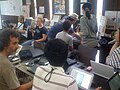 OSM mapping party and workshop in Kamaishi, Japan (September 2012)
 -
 Mapping with Médecins Sans Frontières in the field, in Lubumbashi, Democratic Republic of the Congo, following a remote mapping event in Berlin for Lubumbashi


- Track
- Open Data
- Length of session (if other than 30 minutes, specify how long)
1 1/2 hours
- Will you attend Wikimania if your submission is not accepted?
Yes
- Slides or further information (optional)
- Special requests
Interested attendees
If you are interested in attending this session, please sign with your username below. This will help reviewers to decide which sessions are of high interest. Sign with a hash and four tildes. (# ~~~~).
- Jaredzimmerman (WMF) (talk) 06:33, 31 March 2014 (UTC)
- CristianCantoro (talk) 10:02, 31 March 2014 (UTC)
- SarahStierch (talk) 01:29, 14 April 2014 (UTC)
- Harry Wood (talk) - Experienced OpenStreetMapper (can help teach)
- Of course! —seav (talk) 19:14, 22 April 2014 (UTC)
- --Ayaita (talk) 14:28, 29 April 2014 (UTC)
- Slowking4 (talk) 01:15, 1 May 2014 (UTC)
Enock4seth (talk) 18:38, 23 May 2014 (UTC)- Susannaanas (talk) 13:24, 16 June 2014 (UTC)
- Yiyi (talk) 09:48, 8 July 2014 (UTC)
- Pymouss (talk) 12:03, 22 July 2014 (UTC)
- Bachounda (talk) 13:54, 24 July 2014 (UTC)
- Kolossos (talk) 21:02, 4 August 2014 (UTC)
- Add your username here.